
Map of Our Location and GPS Coordinates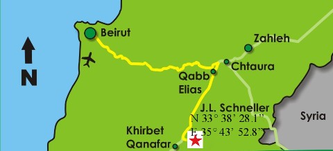
Users of GPS equipment can enter the following coordinates to reach Schneller School: Latitude N 33° 38' 28.1"
Longitude E 35° 43' 52.8"
Useful GPS Coordinates
1- National Evangelical Church (Beirut)
N 33° 53' 41.7"
E 35° 30' 4.1"
2- Supreme Council of Evangelical Churches
N 33° 55' 15.9"
E 35° 35' 51.8"
3- NEST [Near East School of Theology] (Ras Beirut)
N 33° 53' 52.1"
E 35° 28' 56.2"
4- Bible Society (Jdeideh)
N 33° 53' 20.6
E 35° 33' 28.4"
5- Presbyterian Church (Rabieh)
N 33° 55' 15.9"
E 35° 35' 51.8"
6- LES [Lebanese Evangelical Society] (Jdeideh)
N 33° 53' 26.7
E 35° 33' 59.0"
7- BLESSED [Benevolent Lebanese Evangelical School for Special Education and Development] (Achrafieh)
N 33° 53' 20.7"
E 35° 31' 46.6"
8- LESGB [Lebanese Evangelical School for Girls and Boys] (Louweizeh)
N 33° 50' 5.3"
E 35° 34' 8.7"
9- BESGB [Beirut Evangelical School for Girls and Boys] (Rabieh)
N 33° 55' 15.9"
E 35° 35' 51.8"
10- YFC [Youth for Christ] (Dikwaneh)
N 33° 52' 32.4"
E 35° 32' 54.8"
11- YFC [Youth for Christ] (Mazraet Yachouh)
N 33° 55' 37.3"
E 35° 37' 40.3"
12- Baptist School (Mseitbeh)
N 33° 53' 4.1"
E 35° 29' 42.4"